
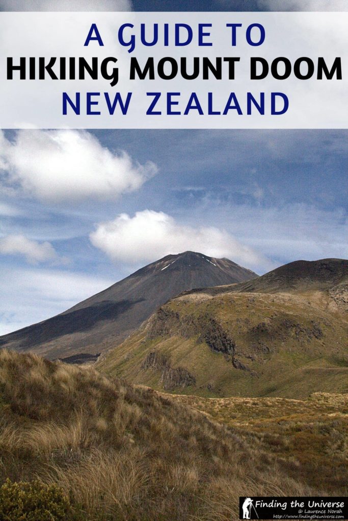
Ok, so I know it’s not really called Mount Doom. Hardy hobbits did not trudge many miles bearing the one ring of power and throw it into the fires of this mountain, which dominates the landscape here for miles around.
Yes, it’s real name is a Maori word: Ngauruhoe (pronounced, from what I can tell, Nara-ho-ee).
But still, you can’t help but peer at it, knowing that actually, in your heart, you consider this to be Tolkien’s mountain, the mountain he would have imagined Doom to be like, had he been thinking of a mountain.
It’s just so… volcanic. When you draw a volcano as a kid, or make one out of papier-mache in an inevitable science class, chances are, it will look just like Mount Ngauruhoe. Perfectly conical sides lead up to the crater rim, and steam obligingly pours off the top to complete the picture.
In this post, I’m going to share with you everything you need to know to both climb Mount Doom, and also hike the Tongariro Crossing, both of which are found on New Zealand north island.
Let’s get to that now, and hopefully answer all your questions!
A Guide to Climbing Mount Doom & Hiking the Tongariro Crossing
Where is Mount Doom in New Zealand?
Mount Doom can be found in the Tongariro National Park on New Zealand’s north island. The way to climb Mount Doom is to do a part of the Tongariro Alpine crossing.
What is the Tongariro Alpine Crossing?
The Tongariro Alpine crossing is one way day hike which crosses the volcanic centre of New Zealand’s North Island, between the summits of Mount Tongariro (1967m) and Mount Ngauruhoe (2287m). It is lauded as New Zealand’s best one day hike.
How Long is the Tongariro Alpine Crossing?
The Tongariro Alpine Crossing is 19.4km / 12 miles in length.
How Long Does the Tongariro Alpine Crossing Take?
Most hikers complete the hike in 6-8 hours, although you can do it faster if you are very fit of course.
The walk itself starts at around 1100m and the main track peaks at around 1880m, with the option of climbing to the summit of both Tongariro and Ngauruhoe as you go.
Are you allowed to climb Mount Doom?
When I did this hike, it was allowed to climb Mount Ngauruhoe. However, as of 2017, the situation has changed a little.
Mount Ngauruhoe, and specifically its peak, is regarded as sacred to the local Maori hapū, Ngāti Hikairo Ki Tongariro. I was not aware of this when I climbed the peak and it was not something that was being made widely known.
In respect of their wishes, DOC rangers removed signs directing visitors to the peak in 2017. Additionally, DOC rangers are usually found on the mountain near the point where you would set off to ascend. They will not stop you from climbing, but they will inform you that it is the wish of the local people that you do not climb.
So, currently, yes you are allowed to climb Mount Doom, but it is your decision as to whether or not you want to.

When I lived in New Zealand, I worked at a location conveniently right between the start and finish of the walk. It was a 20 minute drive to the start, and about a five minute drive from the finish.
So when the weather gave us a good day, with clear skies and barely a breeze in the air, we took a break from our work and headed up to the mountain.
Helpfully, one of the shuttle bus companies (Tongariro Expeditions) was kind enough to give us a lift up with one of their morning runs which go from the park we work in to the car park the walk starts in. And then the walk began.

A Section by Section Guide to the Tongariro Alpine Crossing
The Walk To Mount Ngauruhoe on the Tongariro Alpine Crossing
The scenery, as you can imagine, is absolutely spellbinding. The visibility, even from the relatively low point of the car park at 1100m, was incredible. We could see, for example, Mount Taranaki jutting into the sky, 180km away to our west.
Nearer, Mount Ruapehu, home to what I am informed are the southern hemispheres largest ski fields and also the North Island’s highest mountain, sparkled impressively in the sun, still clad in plenty of clear white snow. The walk was off to an auspicious start.
I will get one thing out of the way now. Being billed as New Zealand’s top one day walk inevitably means that the Tongariro Alpine Crossing is busy.
Even in the quieter part of the season, when we did it, there were plenty of people about. Most folk start the walk between 7am and 9.30am, and as everyone is going the same way along what are often narrow paths, it can be a little congested at times. But then, with scenery like this to look at, there really is no rush.

The walk itself is very well marked, and the track is not too hard. You start off walking from the car park to the Mangatepopo Hut along a giant valley lined with lava flows and boulders, before the first serious ascent, up to the Mangatepopo saddle, which is right between the Tongariro and Ngauruhoe summits.
Around about here is where you break off if you wish to do the Ngauruhoe (or Mount Doom) climb. Which obviously, we did.
Climbing Mount Doom
The bus company brochure describes this part of the walk as “very challenging”, a warning which we assumed was your usual over the top safety conscious stuff.
About 50 metres in, we realised that perhaps it was a serious warning. The “track” we were following rapidly disappeared, the slope inclined to thirty degrees, and we were scrambling up a snow covered scree field, with the summit at least a 500 metre vertical ascent ahead. I began to realise why this part of the walk was both optional and not that busy.
Still, I like to start what I finish, even if that means scrambling up lava flows and loose, slippery boulder covered scree, with nothing but a very long and painful slide behind me should it all go wrong.
About half way up my travelling companion concluded I was completely insane, and left me to it. The sight of other people carrying on bolstered my confidence, even though I had no idea at all how I was going to get back down, and I pressed on, finally making it to the top in just under two hours. And wow, was that worth it.

Steam mysteriously poured out of the ground below my feet, as the snow covered crater rim loomed before me. I circumnavigated the outer and lower part of the rim, stopping to take a lot of photos, before the final push up another fifty metres or so of hard packed snow got me to the top and I was able to peer within.
There was no sign of orcs or dark, twisted evildoers. Just the steam, the rocks, and the smell of sulphur, with a panoramic view of most of New Zealand’s North island. Not bad.
After a spot of food to bolster the spirits, I sledged down the snow on my bum, brushed myself off, and pondered the best way to get down the rest of the way. It turned out, the way down was pretty easy. All I had to do was dig my heels in to the ash filled scree and walk / slide my way down.
It was incredibly fun, and took me about twenty minutes to go down what had taken me nearly two hours to go up. At the bottom I decided I had so enjoyed the walk down that I was tempted to go back up again. Sanity prevailed.

Continuing the Tongariro Alpine Crossing
At this point I re-met my companion, and we set off again on the walk. As most of the walkers had not done Ngauruhoe, we were now over two hours behind everyone else, and thus had much of the rest of the walk almost to ourselves, which was brilliant.
We walked, feeling like ants, across the giant “South crater”, between Ngauruhoe and Tongariro, before starting on the last part of the climb, up the red crater.

The red crater
The red crater is so called because, well, it’s all red. Dark ruby coloured earth contrasted against the startlingly blue sky, as steam poured out of the rocks – the smell of sulphur was heavy in the air. Behind us, Ngauruhoe loomed. We pressed on.
From the top of the red crater – the half way point of the track and it’s highest point – there is an option to ascend another 100m or so on a 3km return trip to the summit of Tongariro, which is a much more popular side option. We elected not to do this as we had to get to the other side of the mountain to catch our four thirty bus home, and didn’t want to have to rush.
From the red crater the track descends to the emerald lakes, aptly named for their mesmerising colours, with snow lining the edge. There you walk across a snow plain (which will melt as the season progresses) before a short ascent up to the gorgeous blue lake, in which large chunks of snow were gently bobbing.
As always, the scenery was just phenomenal, it felt like we were walking on another world. Mars perhaps. Certainly somewhere without trees.

Downhill all the way
From the blue lake it was all downhill – we rounded a corner and lost sight of Ngauruhoe, hidden behind the bulk of Tongariro, and started the long descent.
The long descent is the main reason the walk is only done in one direction, for whilst you start at an altitude of 1100m, you finish at around 700m, and most folk aren’t too keen on tramping up that extra 400m.
Whilst this part of the walk is also staggeringly pretty, with the mass of Lake Taupo laid out before you, and nearly all of the northern half of the North island visible, by this point feet are starting to get tired and folk are thinking of that first cold beer.

The descent takes you past the Ketetahi Hut and the Ketetahi Hot Springs – the latter of which are private Maori land and therefore not accessible to walkers – before the final 6.5km down through the alpine forest and to the car park.
This part of the walk is well known for feeling longer than it is, and you really do start to wonder if you have become lost in a never ending forest trail. All it needed was giant spiders and elves, and Mirkwood would have come to life around me.

This, however, was not to be. We came out into the sunny carpark at the end, around eight hours after we had started to walk, and thankfully climbed onto our bus, which conveyed us back to the park and a blissfully cold beer and warm shower.
I cannot recommend this walk enough. Even if you don’t do the Ngauruhoe summit climb (which is genuinely scary), the views and scenery are truly stunning. It does get very busy though, so if you can find a gloriously sunny day in the quieter months (around Spring time) you may enjoy it more.
You can do the walk in Winter with a guide too, although that’s crampons and ice axe territory, so bring some fitness and warm clothing.
Laurence says
It sure was – and I did take quite a few!
Laurence says
Thanks Amanda! We were incredibly lucky with the weather – since we went up it’s been windy, cold and threatening to snow! When you come out do the walk – I can’t recommend it enough!
Awhina Tours says
Wonderful images and one of the best write-ups on this world class walk. I can see that there is no way I could reach the summit but I do hope to do the traverse.
I believe their is one tour company affiliated with the ancestral owners that can take you to Ketetahi Hut and the Ketetahi Hot Springs.
Amanda Williams says
I can’t begin to tell you how jealous I am! If I can only do one thing the next time I’m in New Zealand, this will be it. Your photos are amazing! You had such a good day for it. I don’t know if I’ll be brave enough to summit Ngauruhoe, though!
Laurence says
I know what you mean! Darn coming to New Zealand without a copy of the
films to hand… Still… They do seem to show fairly regularly on the
local movie channels 😉
Breakaway Backpacker says
OH WOW THAT IS AMAZING! This is def on my too visit list. Great pics~
Now I wanna go see LOTR again.
Awhina Tours says
Wonderful images and one of the best write-ups on this world class walk. I can see that there is no way I could reach the summit but I do hope to do the traverse.
I believe their is one tour company affiliated with the ancestral owners that can take you to Ketetahi Hut and the Ketetahi Hot Springs.
Laurence says
@Awhina Tours – Thanks for the kind words 🙂 We took a stroll from the
Ketetahi carpark up to the Ketetahi hut yesterday to get a reverse view
of the hot springs – it really is quite amazing to see steam pouring out
of the side of the hill. Would love to get closer!
Amanda Williams says
I can’t begin to tell you how jealous I am! If I can only do one thing the next time I’m in New Zealand, this will be it. Your photos are amazing! You had such a good day for it. I don’t know if I’ll be brave enough to summit Ngauruhoe, though!
Laurence says
Thanks Amanda! We were incredibly lucky with the weather – since we went up it’s been windy, cold and threatening to snow! When you come out do the walk – I can’t recommend it enough!
Sarah Wu says
wow, that’s like a photographer’s heaven. Beautiful view to take pictures!
Sarah Wu says
wow, that’s like a photographer’s heaven. Beautiful view to take pictures!
Laurence says
It sure was – and I did take quite a few!
Laurence says
@Caz and Craig – cheers guys, it was truly amazing 😀
@Ant – I didn’t! I wish I had been aware, I would have scoured the surface of the mountain 🙂 I lost both of my big toe nails whilst tramping around Australia, it’s not pretty stuff!
Ant Stone says
Oh, Ngauruhoe. You didn’t happen to find my big toe nail, and both of my girlfriend’s as well, did you? We lost them doing this same tramp over Easter.
Ant Stone says
Oh, Ngauruhoe. You didn’t happen to find my big toe nail, and both of my girlfriend’s as well, did you? We lost them doing this same tramp over Easter.
yTravel Blog says
Sounds like a really incredible hike Laurence. I would love to do this. Thank you for drawing it to my attention. Amazing photos as well
Caz Craig Makepeace says
Sounds like a really incredible hike Laurence. I would love to do this. Thank you for drawing it to my attention. Amazing photos as well