
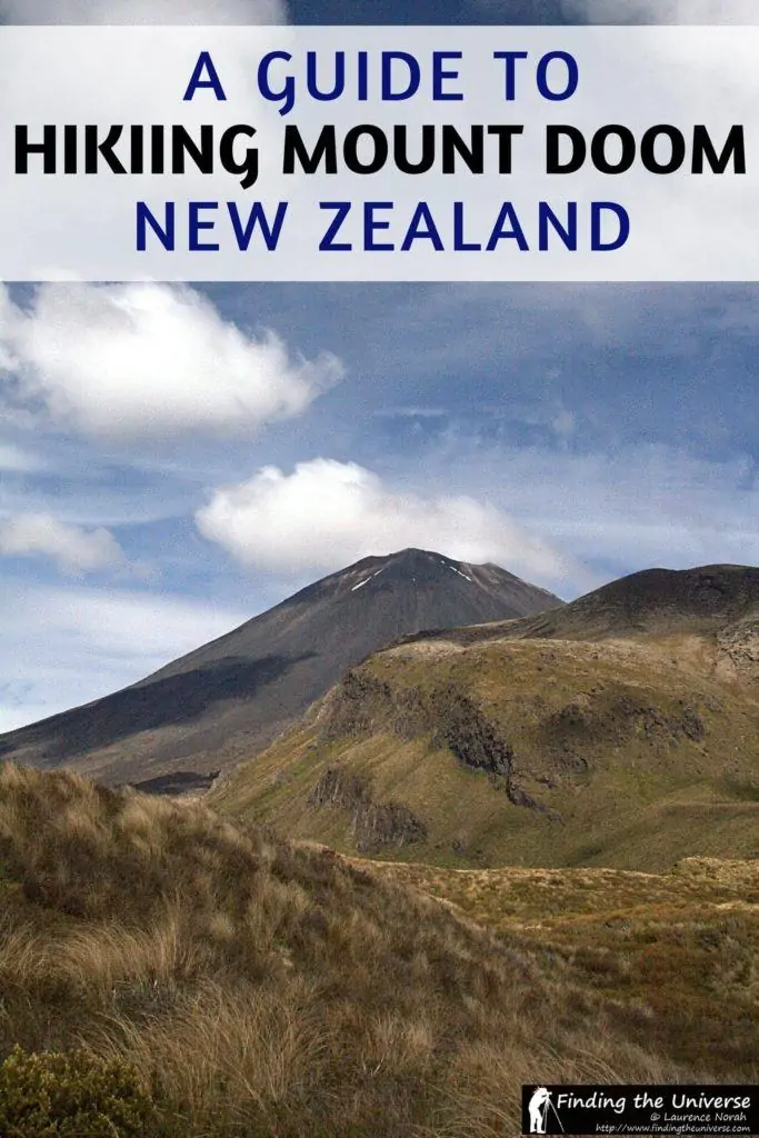
Ok, so I know it’s not really called Mount Doom. Hardy hobbits did not trudge many miles bearing the one ring of power and throw it into the fires of this mountain, which dominates the landscape here for miles around.
Yes, its real name is a Māori word: Ngauruhoe (pronounced Ngoh-roo-haw-e, see a full explanation in this comment).
But still, you can’t help but peer at it, knowing that actually, in your heart, you consider this to be Tolkien’s mountain, the mountain he would have imagined Doom to be like, had he been thinking of a mountain.
It’s just so… volcanic. When you draw a volcano as a kid, or make one out of papier-mâché in an inevitable science class, chances are it will look just like Mount Ngauruhoe. Perfectly conical sides lead up to the crater rim, and steam obligingly pours off the top to complete the picture. It’s one of the North Island stops in our guide for first-time visitors to New Zealand.
I lived and worked near this mountain for a year, back in 2010-2011. In that time I hiked the Tongariro Alpine Crossing, climbed to the summit of Ngauruhoe, and visited more Lord of the Rings filming locations than I can count. This post is my guide to everything you need to know about hiking the Tongariro Crossing and visiting Mount Doom in New Zealand.
A lot has changed since I first did this hike. There’s now a booking system, new parking restrictions, updated shuttle logistics, and an important cultural conversation about whether you should climb the summit at all. I’ve updated this guide to reflect all of that, while keeping the personal account of my own experience on the mountain.
Table of Contents:
Where is Mount Doom in New Zealand?
Mount Doom (Mount Ngauruhoe) is in the Tongariro National Park on New Zealand’s North Island. It sits between the summits of Mount Tongariro to the north and Mount Ruapehu to the south, roughly in the centre of the island.
The most common way to see Mount Ngauruhoe up close is to hike the Tongariro Alpine Crossing, a one-way day hike that passes right by the base of the mountain.
Mount Ngauruhoe and Māori Cultural Significance
Before I get into the practicalities, there’s something important to cover.
Mount Ngauruhoe, and specifically its summit, is sacred to the local Māori hapū, Ngāti Hikairo ki Tongariro. The mountain holds deep cultural and spiritual significance as a connection between the people and their ancestors.
When I climbed the peak back in 2010, this wasn’t widely communicated. There were no signs discouraging the climb, and I didn’t know about the cultural significance at the time. That has changed considerably.
In 2017, the Department of Conservation (DOC) removed all signs directing visitors to the summit. DOC rangers and representatives from Ngāti Hikairo ki Tongariro now regularly patrol near the point where hikers would branch off to climb, particularly during peak season from November to April. They won’t physically stop you, but they will explain the cultural significance and ask you to reconsider.
Some shuttle companies operating under DOC concessions may also decline to transport you if you tell them you intend to climb the summit.
It is not illegal to climb Mount Ngauruhoe. But you should understand the context before making that decision. The local iwi have made a clear, respectful request, and it’s worth taking that seriously.
I’ve kept my personal account of climbing the summit below, because it happened, it’s part of the story, and people are going to search for this information regardless. But I want to be upfront: the Tongariro Alpine Crossing is an incredible experience without the summit climb. If I were doing it for the first time today, I’d give the summit a lot more thought than I did in 2010. I will leave the choice up to you.

What is the Tongariro Alpine Crossing?
The Tongariro Alpine Crossing is a one-way day hike that crosses the volcanic centre of New Zealand’s North Island, passing between the summits of Mount Tongariro (1,967m) and Mount Ngauruhoe (2,287m). It’s widely considered one of the best day hikes in the world, and for good reason.
The track is around 20km (12.5 miles) in length and takes most hikers 6 to 8 hours to complete. You start at the Mangatepopo road end at around 1,120m elevation and finish at the Ketetahi road end at around 760m. The highest point on the main track is Red Crater at 1,886m.
Along the way you’ll walk through volcanic valleys, past lava flows and steaming vents, up the infamous Devil’s Staircase, across the surreal South Crater, and past the Emerald Lakes and Blue Lake before descending through alpine tussock and native forest. The scenery changes constantly and I don’t think there was a single section where I got bored.
How to Book the Tongariro Alpine Crossing
This is a big change from when I did the hike. Since October 2023, DOC has had a booking system in place for the Tongariro Alpine Crossing.
The booking is free and there’s currently no cap on daily numbers, though that’s expected to change in the future. From late 2027, there will be a small fee for international visitors (it remains free for New Zealanders).
You need to complete the booking through the DOC website before your hike. One booking covers your whole group. If you’re using a shuttle service, you’ll need your DOC booking reference to complete the shuttle reservation.
Getting There: Shuttles and Parking
Because the Tongariro Alpine Crossing is a one-way hike (you start and finish in different places), you need to sort out transport. You can’t just drive to the start and walk back to your car.
There are also 4-hour parking restrictions at both the Mangatepopo (start) and Ketetahi (end) car parks during the summer season. During peak months, you can’t park at Mangatepopo at all if you’re doing the full crossing.
There are two main options:
Option 1: Ketetahi car park + shuttle (easiest for drivers). Drive to the private car park near the Ketetahi end of the track. Secure parking here includes a shuttle to the Mangatepopo start point. You hike the crossing and walk back to your car at the other end. No time pressure, no waiting for a return bus.
Option 2: Return shuttle from your accommodation. Multiple companies run return shuttles from the nearby towns of Waimarino (formerly National Park Village), Tūrangi, Taupo, and Ohakune. They’ll drop you at the Mangatepopo start and collect you from Ketetahi when you’re done. The downside is you’re on their schedule, so you may end up waiting at the finish.
Shuttle prices are around NZ$55 per person for a return service from Waimarino. Companies include Tongariro Crossing Shuttles, Tongariro Expeditions (the company that gave me a lift back in 2010, still going strong with over 25 years of experience), and Summit Shuttles among others.
I’d recommend booking your shuttle well in advance during summer, especially if you want an early departure. The earlier you start, the quieter the track will be.
A Section by Section Guide to the Tongariro Alpine Crossing
When I lived in New Zealand, I worked at a location conveniently right between the start and finish of the walk. It was a 20 minute drive to the start, and about a five minute drive from the finish.
So when the weather gave us a good day, with clear skies and barely a breeze in the air, we took a break from work and headed up to the mountain. It was spring, probably October, and there was still snow on the higher ground.

Mangatepopo Valley to the Devil’s Staircase
The scenery, as you can imagine, is spellbinding. The visibility, even from the relatively low point of the car park at 1,100m, was incredible. We could see Mount Taranaki jutting into the sky 180km away to our west.
Nearer, Mount Ruapehu, home to the North Island’s highest peak and its ski fields, sparkled impressively in the sun, still clad in clear white snow. The walk was off to a good start.
I will get one thing out of the way now. Being billed as New Zealand’s top one day walk inevitably means that the Tongariro Alpine Crossing is busy. Even in the quieter part of the season, when we did it, there were plenty of people about. Most people start between 7am and 9.30am, and as everyone is going the same way along what are often narrow paths, it can be a little congested at times. But then, with scenery like this to look at, there really is no rush.

The walk itself is very well marked, and the track is not too hard to start with. You begin by walking from the car park to the Mangatepopo Hut along a broad valley lined with lava flows and boulders, before the first serious ascent: the Devil’s Staircase, which takes you up to the saddle between Tongariro and Ngauruhoe.
The Devil’s Staircase is about 30 minutes of sustained climbing with no respite. It’s not technical, just relentless. Around the top of the staircase is where you reach South Crater, and where you’d branch off if you were going to attempt the Ngauruhoe summit climb.
Climbing Mount Doom (Mount Ngauruhoe)
Please read the section above on Māori cultural significance before deciding whether to do this.
The bus company brochure described this part of the walk as “very challenging”, a warning which we assumed was the usual over the top safety conscious stuff.
About 50 metres in, we realised that perhaps it was a serious warning. The “track” we were following rapidly disappeared, the slope inclined to thirty degrees, and we were scrambling up a snow covered scree field, with the summit at least a 500 metre vertical ascent ahead. I began to realise why this part of the walk was both optional and not that busy.
Still, I like to finish what I start, even if that means scrambling up lava flows and loose, slippery boulder covered scree, with nothing but a very long and painful slide behind me should it all go wrong.
About halfway up, my travelling companion concluded I was completely insane and left me to it. The sight of other people carrying on kept me going, even though I had no idea at all how I was going to get back down, and I pressed on, finally making it to the top in just under two hours. And wow, was that worth it.

Steam mysteriously poured out of the ground below my feet, as the snow covered crater rim loomed before me. I circumnavigated the outer and lower part of the rim, stopping to take a lot of photos, before the final push up another fifty metres of hard packed snow got me to the top and I was able to peer within.
There was no sign of orcs or dark, twisted evildoers. Just the steam, the rocks, and the smell of sulphur, with a panoramic view of most of New Zealand’s North Island. Not bad.
After some food to bolster the spirits, I sledged down the snow on my bum, brushed myself off, and pondered the best way to get down the rest of the way. It turned out, the way down was surprisingly easy. All I had to do was dig my heels in to the ash-filled scree and walk/slide my way down.
It was incredibly fun, and took me about twenty minutes to go down what had taken me nearly two hours to go up. At the bottom I decided I had so enjoyed the walk down that I was tempted to go back up again. Sanity prevailed.

If you do decide to climb, be aware that there is no marked track. The scree is loose and exhausting on the way up. People have been seriously injured and killed on this mountain. The weather can change rapidly. You should be experienced, well-equipped, and prepared to turn back. The summit climb adds roughly 3 hours to the crossing (2 hours up, under an hour down), so factor that into your shuttle timing.
South Crater to Red Crater
At this point I re-met my companion, and we set off again on the walk. As most of the walkers had not done Ngauruhoe, we were now over two hours behind everyone else, and thus had much of the rest of the walk almost to ourselves. Brilliant.
We walked, feeling like ants, across the giant South Crater between Ngauruhoe and Tongariro, before starting on the last part of the climb up to Red Crater.

The Red Crater and Emerald Lakes
The Red Crater is so called because, well, it’s all red. Dark ruby coloured earth contrasted against the startlingly blue sky, as steam poured out of the rocks and the smell of sulphur hung heavy in the air. Behind us, Ngauruhoe loomed.
From the top of the Red Crater, the highest point of the main track at 1,886m, there’s an option to make a 3km return side trip to the summit of Tongariro itself. We elected not to do this as we had to get to the other side of the mountain to catch our bus, and didn’t want to rush.
From Red Crater the track descends steeply on volcanic scree to the Emerald Lakes, aptly named for their mesmerising colours, with snow lining the edges. You then walk across a flat area before a short ascent to the gorgeous Blue Lake, in which large chunks of snow were gently bobbing. The Blue Lake is tapu (sacred), so don’t swim in it or eat food around its shores.
As always, the scenery was just phenomenal. It felt like we were walking on another world. Mars, perhaps. Somewhere without trees, at any rate.

The Descent
From the Blue Lake it was all downhill. We rounded a corner and lost sight of Ngauruhoe, hidden behind the bulk of Tongariro, and started the long descent.
The long descent is the main reason the walk is only done in one direction. You start at 1,120m and finish at around 760m, and most people aren’t too keen on tramping up that extra distance at the end of the day.
The track passes the site of the old Ketetahi Hut, which was damaged in a volcanic eruption in 2012 and has since been removed (toilets are still there, though). The Ketetahi Hot Springs are nearby but on private Māori land and not accessible to walkers, so stay on the track.
The final 6.5km takes you down through alpine forest to the Ketetahi car park. This part of the walk is well known for feeling longer than it is, and you really do start to wonder if you have become lost in a never ending forest trail. All it needed was giant spiders and elves, and Mirkwood would have come to life around me.

This, however, was not to be. We came out into the sunny car park at the end, around eight hours after we had started, and thankfully climbed onto our bus, which conveyed us back and into the arms of a cold beer and warm shower.

What to Bring on the Tongariro Alpine Crossing
The Tongariro Alpine Crossing passes through active volcanic terrain at altitude. Weather can change very quickly, and the conditions at Red Crater can be completely different from what you left behind at the car park. This track has the highest number of search and rescue incidents for hikers in New Zealand, so come prepared.
You’ll want: sturdy hiking boots (not trainers), waterproof jacket, warm layers (even in summer), sun protection (hat, sunscreen, sunglasses), at least 2 litres of water, food for a full day, and a fully charged phone. If you’re planning the summit climb, bring additional water and consider gloves for the scramble.
There are toilets at the Mangatepopo car park, near Soda Springs, at the old Ketetahi Hut site, and at the Ketetahi road end. There are no rubbish bins anywhere on the track, so bring a bag and take everything out with you.
The November 2025 Fires
In November 2025, a wildfire burned through nearly 3,000 hectares of Tongariro National Park. A second fire in December burned a further 300 hectares. The fires were devastating to the park’s fragile alpine ecosystem.
In response, Ngāti Hikairo ki Tongariro placed a 10-year restorative rāhui over the fire-affected area. It’s worth understanding what this means: the rāhui is not about keeping people out. It’s about the long-term healing of the land, and about ensuring that restoration work can happen without the pressure of rushing back to normal for tourism.
The Tongariro Alpine Crossing has reopened and is fully accessible. You will see blackened landscapes and burnt vegetation along parts of the trail, particularly near the Mangatepopo start, but you’ll also see regrowth beginning. Hapū representatives and Manaaki Rangers greet visitors daily during summer to share the story of the mountain and the recovery effort.
If you’d like to contribute to the restoration, the New Zealand Nature Fund is accepting donations to support the recovery work.
When is the Best Time to Hike the Tongariro Crossing?
The main hiking season runs from October to April, which is when shuttle services operate. December to February is peak summer with the most settled weather, but also the biggest crowds.
I did the crossing in spring (around October), and there was still snow on the higher ground. The advantage was far fewer people on the track, particularly once we fell behind the main pack by climbing Ngauruhoe.
You can hike the crossing in winter (May to September), but you’ll need crampons, an ice axe, and alpine experience, or a guide. Shuttle services don’t run in winter, but the 4-hour parking restrictions at the road ends don’t apply either.
Whatever time of year you go, check the weather forecast the day before and be prepared to postpone if conditions aren’t suitable. The Tongariro National Park Visitor Centre can advise on current conditions.
Further Reading for Your New Zealand Trip
If you found this post helpful, you might like to check out some of my other New Zealand content. I spent a year in the country and covered a fair bit of ground:
For more filming locations, see my guide to the Lord of the Rings filming locations in New Zealand. I also have guides to the must-see attractions on the South Island, the best day hikes in New Zealand, and a complete one-month New Zealand itinerary to help you plan your trip.
I cannot recommend the Tongariro Alpine Crossing enough. Even if you skip the Ngauruhoe summit climb, the views and scenery are some of the best I’ve experienced anywhere in the world. It does get very busy, so if you can find a gloriously sunny day in the quieter months, you may enjoy it more. Tongariro is one stop on a longer route, and our North Island itinerary highlights piece covers where else to fit in on a bigger trip.
Frequently Asked Questions
Can you climb Mount Doom in New Zealand?
It is not illegal to climb Mount Ngauruhoe (Mount Doom), but the local Māori hapū, Ngāti Hikairo ki Tongariro, have asked visitors not to summit the mountain out of respect for its cultural and spiritual significance. DOC removed trail markers to the summit in 2017, and rangers are often present during peak season to explain the situation.
If you do choose to climb, be aware there is no marked route. The scree is loose and the ascent is physically demanding, adding roughly 3 hours to the crossing. People are injured on the mountain every year.
Do you need to book the Tongariro Alpine Crossing?
Yes, a booking through the DOC website is recommended for all hikers and required if you want to use a shuttle or guided walk service. The booking is free and there is currently no limit on daily numbers. You’ll need your DOC booking reference to book a shuttle.
How hard is the Tongariro Alpine Crossing?
DOC rates the main track as intermediate. It’s around 20km with about 760m of elevation gain and the highest point at 1,886m. Most hikers complete it in 6 to 8 hours. You need a reasonable level of fitness and proper hiking gear. The weather can change rapidly at altitude, so preparation is important.
Where do you park for the Tongariro Crossing?
Both DOC car parks (Mangatepopo and Ketetahi) have 4-hour time limits during summer, so you can’t park at the start and hike the full crossing. The easiest option for drivers is to park at the private Ketetahi car park (near the finish), which includes a shuttle to the Mangatepopo start. Alternatively, book a return shuttle from your accommodation in Waimarino, Tūrangi, Taupo, or Ohakune.
How much does the Tongariro Crossing cost?
The hike itself is free (with a mandatory free booking via DOC). Shuttle costs are around NZ$55 per person for a return service from Waimarino. Private car park and shuttle packages are a similar price. From late 2027, international visitors will pay a small fee to walk the crossing.
Christine Sedunary says
Hi there,
I was 58 when I did this walk. It was a random decision. The next day I walked it without any actual training or fitness other than a daily half hour walk. It took me no longer than anyone else really. I didn’t find it scary, or really that steep, but it was hard sliding down that scree until someone was kind enough to lend me their walking poles and that made all the difference. So to that man, I am very grateful and I hope he got them back. It was a great experience especially with so many people there doing it as well. All fun and cheer and what’s more I met young friends and felt fitter at the end of the day than when I started.
It was amazing…Christine
Laurence Norah says
Hi Christine,
Glad to hear you had a great experience and thanks very much for sharing it with us! Safe travels 🙂
Laurence
Sauron says
Hi, the proper pronunciation for Mt Ngauruhoe is actually like “Ngoh-roo-haw-e” the ng isn’t an ‘n’ but rather ‘ng’ like at the end of ‘sing’. The ‘a’ in Māori is pronounced like ‘aaaah’ and the ‘u’ is said exactly like the end of the word ‘you’ but without the ‘y’, so ‘oooh’; and when combined together the ‘au’ is very similar to the word ‘oh’ so thats an easier way to remember it au=oh. the ‘r’ and the ‘u’ together make a roo sound but you need to roll the ‘r’ like you would in Spanish. The ‘ho’ is pretty similar to ‘haw’ but not like how Americans would say it, but rather like the British. And then very easy, ‘e’ which would be the ‘e’ sound in bed, said, red, (in a kiwi accent, mind you, as everyone else in the world pronounces their e’s differently than we do) and there you go, Ngauruhoe=Ngoh-roo-haw-e
Laurence Norah says
Hey Sauron, thank you so much for this, much appreciated! I will update the post to make it clear 🙂
Jo says
Hello!
I’m heading to North Island in a few weeks and am sitting on the fence about this hike. It sounds and looks amazing, and as an avid LOTR fan, I would love to trek through Mordor and pretend drop my ring into Mt Doom; however, would you advise it for someone who has never done a proper mountain hike before? Also have had a minor foot injury about 9 mths ago and it randomly hurts once in a while. And I will have to buy hiking boots which I will only have 2 free days to walk around in to break into. I saw some comments about losing toenails here – is that likely to happen if we don’t opt to climb the actual Mt Ngauahoe?
Thanks!
Laurence Norah says
Hey Jo,
It is definitely an amazing hike, and it is very popular even with folks who don’t do a lot of hiking. So there will be plenty of people on the trail. That said, it is quite a hike with ascents and descents, and whilst there’s no actual climbing you are going to be spending the majority of the day on the trail. I didn’t personally lose a toenail, but it is not uncommon, it happened to a friend of mine. There’s a lot of up and down and uneven terrain, so it’s not hard to bang your foot especially as you get more tired!
All that said I do absolutely think it’s worth it and worth some discomfort, although you will have to judge your own personal fitness level and injury before making the decision!
Have a great time in New Zealand regardless!
Laurence
Chloe says
Nearly 18 years after doing this hike and climbing up Mount Ngauruhoe I can still remember the fear of the ascent and decent and wondering how on earth I was going to get down once I reached the top. On the ascent I was finally reduced to crawling up on my hands and knees like Gollum :O) It’s so reassuring to see that I wasn’t a complete wimp and that others found it equally challenging; thank you :O) And thank you for reviving memories of an incredibly beautiful walk.
Happy hiking everyone but take care xx
Laurence Norah says
Ah yes, it was definitely challenging and quite scary! But I did enjoy it a great deal. Glad to bring back some happy memories for you 😀 Safe hiking!
Irene says
Hi! And thank you for such a great post! 🙂 I am travelling to NZ next week and really want to see Mount Doom – or Mount Ngauruhoe if you wish. Hehe:-) Unfortunately, we do not have enough time in our itinerary to fit a hike – but I figured that maybe we might be able to see Mount Ngauruhoe anyway as we will be driving from Matamata to Wellington one of the days. Is it possible to see the mountain from the Mangatepopo car park? If not, how far in on the hike do you have to go to get an OK view of it? Thank you so much for your time and help – and have a lovely day! – Irene
Laurence Norah says
Hi Irene,
You can definitely see it from the car park, and from much further away as well. It’s one of the largest mountains in the area, so you will be able to see if from some way away (depending on the angle of course).
Have a great trip!
Laurence
David Badger says
Hi,
You mention the fabulous view across to Mt Taranaki ‘to your south-east’. Seems to me that Mt Taranaki is in fact west of Tongariro (maybe slightly south of west, but definitely not south-east.)
Planning to hike the crossing in November 2019, so thanks for the detailed description.
Laurence Norah says
Hi David!
Oops! Well, this article has been live for almost a decade and no-one has spotted this until now, so well done! I happily admit to being pretty poor at directions. The article is still valid though, and I’ve fixed that issue. If you do notice any changes when you are there, please do let me know so I can be sure it’s accurate for other readers!
Have an amazing time in New Zealand,
Laurence
Jason says
Thanks for the info it really helped. I do have one question I have read on the other sites that you can no longer climb mount nguaruhoe because they have rangers there. Is this true. Is there a way around this I really want to go to the top. I will be there Jan 2020.
Laurence Norah says
Hi Jason,
From what I have read you are still allowed to climb it, however you are encouraged not to by the rangers due to the significance of the mountain to the local people. Obviously the significance of the mountain has not changed, but this system was not in place when I climbed the mountain back in 2010, and I wasn’t aware of this. The rangers will not actually stop you if you want to climb it though from what I have read, they will just advise you that it is preferred if you don’t.
I hope this helps. If you do go and try to climb it and are able to provide me with an update that would be very helpful,
Thanks!
Laurence
Cassidy says
What kind of footwear would you recommend using in December?
Laurence Norah says
Hi Cassidy,
It will be pretty warm in December as it’s mid summer. However, I always prefer to do a long hike like this in proper hiking boots as you get good ankle support and grip. So that would be my recommendation 🙂
Have a great hike!
Laurence
christine says
Hi Laurence, thank you for the detailed article!! That is amazing you pushed yourself to continue up… despite being left to go alone!
May I ask what size pack you carried on this trip up Ngauruhoe? (and I assume you carried at least 2-3L of water?)
I plan to go the same season, in October. Thank you!
Laurence Norah says
Hi Christine,
I just carried an Osprey day pack, I think it’s 25L. So not too big. I generally carry around 3 litres of water for a day hike like this. although it wasn’t too hot in October.
have a great trip!
Laurence
C Yeh says
That lake is not lake Taupo, but lake rotoaira.
Laurence Norah says
Hey there, and thanks for the comment. Could you let me know which lake you mean?
Laurence says
Wonderful – thanks for sharing! Always good to have feedback to help others 😀
Naga says
Thank you. In fact I did the hike on snow and ice with a group and 2 guides on the same day as planned. It was the best in my life. I saw 3 people climbing Mt Doom and it seemed a tough climb only for professionals. I hope to climb it in summer.
Laurence says
Must have missed this question – sorry! We did this in early October, when there was still some snow but not too much. It’s possible to do the whole crossing in the snow, but requires more preparation and a knowledge of mountaineering in the snow, so we wouldn’t advise it unless you really know what you’re doing 🙂
Naga says
Hi guys, I am planning to do this walk on Sep 11, 2016. I wonder if it is possible to climb Mt Doom if there is snow. When did you do this hike? Thanks for the nice post with beautiful photos.
Laurence says
Thanks Ross! From my experience, March should be clear and easy, there shouldn’t be any snow at that time of year (although of course conditions can change!), so just take plenty of water and allow plenty of time. It’s an amazing hike!
Ross Lambrecht says
Hey Laurence! Awesome photos and description! I’m researching this climb right now in preparation to do it myself, and this post is actually one of the most helpful resources I’ve found online, in terms of a specific account of the climb itself. Since you worked in the area for a while, I’m wondering if you might be able to advise on general weather conditions here in mid-March? Hoping to make the climb then, but having a hard time determining how cold/snowy the mountain will be at this point. Any insights? Thanks for sharing!
Naga says
Hi guys, I am planning to do this walk on Sep 11, 2016. I wonder if it is possible to climb Mt Doom if there is snow. When did you do this hike? Thanks for the nice post with beautiful photos.
Laurence says
Must have missed this question – sorry! We did this in early October, when there was still some snow but not too much. It’s possible to do the whole crossing in the snow, but requires more preparation and a knowledge of mountaineering in the snow, so we wouldn’t advise it unless you really know what you’re doing 🙂
Naga says
Thank you. In fact I did the hike on snow and ice with a group and 2 guides on the same day as planned. It was the best in my life. I saw 3 people climbing Mt Doom and it seemed a tough climb only for professionals. I hope to climb it in summer.
Laurence says
Wonderful – thanks for sharing! Always good to have feedback to help others 😀
Ross Lambrecht says
Hey Laurence! Awesome photos and description! I’m researching this climb right now in preparation to do it myself, and this post is actually one of the most helpful resources I’ve found online, in terms of a specific account of the climb itself. Since you worked in the area for a while, I’m wondering if you might be able to advise on general weather conditions here in mid-March? Hoping to make the climb then, but having a hard time determining how cold/snowy the mountain will be at this point. Any insights? Thanks for sharing!
Laurence says
Thanks Ross! From my experience, March should be clear and easy, there shouldn’t be any snow at that time of year (although of course conditions can change!), so just take plenty of water and allow plenty of time. It’s an amazing hike!
Laurence says
@Awhina Tours – Thanks for the kind words 🙂 We took a stroll from the
Ketetahi carpark up to the Ketetahi hut yesterday to get a reverse view
of the hot springs – it really is quite amazing to see steam pouring out
of the side of the hill. Would love to get closer!
Laurence says
I know what you mean! Darn coming to New Zealand without a copy of the
films to hand… Still… They do seem to show fairly regularly on the
local movie channels 😉
Laurence Norah says
My pleasure! Have an amazing trip, let me know if you have any more questions. I’d also recommend checking out Young Adventures, she is based in New Zealand and does lots of hiking 🙂
Jim says
Thank you so much for such a prompt reply Laurence!
Laurence Norah says
Hey Jim. When I was there, it was a fairly serious undertaking to do the trek in Winter. There are some very steep sections of the track and most of it is snow covered at that time of year, so I don’t believe it is advisable to tackle without the correct gear. The weather is very changeable up there as well. In addition, as it’s a one-way hike (unless you turn around), you still need to arrange transport from one end to the other.
My advice, if you really want to do it, is to go with one of the operators who offer winter treks up here. There was at least one doing this when I was there, who will give you all the equipment and ensure you get through safely 🙂 Hope this helps!
Jim says
Hi Laurence,
My fiancee and I are heading to the North Island at the very end of August and into the first week of September for part of our honeymoon. The Tongariro Alpine Crossing is one of our top activities we would love to be able to do…from what I have read, do you have any insight on whether or not we could reasonably expect to hike large sections of the track without any special winter hiking gear such as crampons etc? Is the snow and ice more of an issue at the peaks an highest altitudes? Or will most of the track be covered? We are both very fit and experienced hikers, but will not have any special equipment with us. Any insight you have would be greatly appreciated. Thanks in advance!
Jeremy Branham says
That’s an amazing hike! I love hiking but this definitely looks like a scene from another world. I’ve had my share of tough hikes but sliding down the snow would be a fun way to get down. Quite a diverse landscape with lots of great views. If I make it to NZ, I will definitely check out this hike.
Mary @ Green Global Travel says
We’ve seen a lot of volcanoes in our travels, but never had a chance to climb one. Wow, thanks for going to all that effort so that we too could enjoy the spectacular scenery.
Laurence Norah says
It’s a funky place for snowboarding I’m told! And three hours from there… that’s pretty much anywhere on the North Island 😛 Whereabouts are you guys from?
Cole @ Four Jandals says
You got your pronunciation right 🙂 Still haven’t done that hike even though it’s only 3 hours from my house. We do go snowboarding there every year though!
Laurence says
@Caz and Craig – cheers guys, it was truly amazing 😀
@Ant – I didn’t! I wish I had been aware, I would have scoured the surface of the mountain 🙂 I lost both of my big toe nails whilst tramping around Australia, it’s not pretty stuff!
Laurence says
It sure was – and I did take quite a few!
Laurence says
Thanks Amanda! We were incredibly lucky with the weather – since we went up it’s been windy, cold and threatening to snow! When you come out do the walk – I can’t recommend it enough!
Awhina Tours says
Wonderful images and one of the best write-ups on this world class walk. I can see that there is no way I could reach the summit but I do hope to do the traverse.
I believe their is one tour company affiliated with the ancestral owners that can take you to Ketetahi Hut and the Ketetahi Hot Springs.
Amanda Williams says
I can’t begin to tell you how jealous I am! If I can only do one thing the next time I’m in New Zealand, this will be it. Your photos are amazing! You had such a good day for it. I don’t know if I’ll be brave enough to summit Ngauruhoe, though!
Laurence says
I know what you mean! Darn coming to New Zealand without a copy of the
films to hand… Still… They do seem to show fairly regularly on the
local movie channels 😉
Breakaway Backpacker says
OH WOW THAT IS AMAZING! This is def on my too visit list. Great pics~
Now I wanna go see LOTR again.
Awhina Tours says
Wonderful images and one of the best write-ups on this world class walk. I can see that there is no way I could reach the summit but I do hope to do the traverse.
I believe their is one tour company affiliated with the ancestral owners that can take you to Ketetahi Hut and the Ketetahi Hot Springs.
Laurence says
@Awhina Tours – Thanks for the kind words 🙂 We took a stroll from the
Ketetahi carpark up to the Ketetahi hut yesterday to get a reverse view
of the hot springs – it really is quite amazing to see steam pouring out
of the side of the hill. Would love to get closer!
Amanda Williams says
I can’t begin to tell you how jealous I am! If I can only do one thing the next time I’m in New Zealand, this will be it. Your photos are amazing! You had such a good day for it. I don’t know if I’ll be brave enough to summit Ngauruhoe, though!
Laurence says
Thanks Amanda! We were incredibly lucky with the weather – since we went up it’s been windy, cold and threatening to snow! When you come out do the walk – I can’t recommend it enough!
Sarah Wu says
wow, that’s like a photographer’s heaven. Beautiful view to take pictures!
Sarah Wu says
wow, that’s like a photographer’s heaven. Beautiful view to take pictures!
Laurence says
It sure was – and I did take quite a few!
Laurence says
@Caz and Craig – cheers guys, it was truly amazing 😀
@Ant – I didn’t! I wish I had been aware, I would have scoured the surface of the mountain 🙂 I lost both of my big toe nails whilst tramping around Australia, it’s not pretty stuff!
Ant Stone says
Oh, Ngauruhoe. You didn’t happen to find my big toe nail, and both of my girlfriend’s as well, did you? We lost them doing this same tramp over Easter.
Ant Stone says
Oh, Ngauruhoe. You didn’t happen to find my big toe nail, and both of my girlfriend’s as well, did you? We lost them doing this same tramp over Easter.
yTravel Blog says
Sounds like a really incredible hike Laurence. I would love to do this. Thank you for drawing it to my attention. Amazing photos as well
Caz Craig Makepeace says
Sounds like a really incredible hike Laurence. I would love to do this. Thank you for drawing it to my attention. Amazing photos as well