
Route 66 is without doubt one of the world’s most legendary roads, and driving the entire 2,400 miles of it was something I’d always wanted to do. In mid-2015, Jess and I finally did it, from Santa Monica in California up to Chicago, Illinois. Then we tacked on an adventure retracing the Oregon Trail (which we managed to survive without catching dysentery), because, well, why not?
This post kicks off our eight-part series of photos from Route 66, covering each of the eight states the road passes through. California has about 315 miles of Route 66 between the Arizona border at Needles and the Santa Monica Pier. Allow at least two days for this section, and more if you want to explore the Mojave properly.
2026 is Route 66’s centennial year (the road was commissioned on November 11, 1926), and California has celebrations running all year. The Main Street of America Centennial Caravan launches from Santa Monica in June, there’s a car show at Roy’s Motel in Amboy, and the Route 66 Cruisin’ Reunion fills the streets of Ontario every September. It’s a good year to drive the Mother Road.
We drove the route from California to Chicago (yes, the wrong way round), and I photographed everything along the way. Below are our California highlights, ordered roughly east to west so they match the traditional Chicago-to-LA direction most people drive. You can also buy prints of many of these images from my Route 66 photo gallery.
For detailed day-by-day planning, see Jess’s 2-week Route 66 itinerary and our Route 66 planning guide.
Table of Contents:
Route 66 in California: All the Highlights
From the Arizona border at Needles, the Mojave Desert stretches ahead with Roy’s Motel in Amboy about 75 miles in. Amboy Crater is right there too.
Another 50 miles gets you to Bagdad Cafe in Newberry Springs, then it’s about 30 miles into Barstow and the Harvey House.
Elmer’s Bottle Tree Ranch in Oro Grande is 35 miles from Barstow, Calico Ghost Town is a short detour off I-15, and from there it’s 30 miles to Victorville and its Route 66 Museum.
San Bernardino with the first McDonald’s and the Wigwam Motel is another 40 miles south through the Cajon Pass, and then it’s city driving through the Inland Empire and Los Angeles to the Santa Monica Pier.
The desert half is the photogenic half. The city half is the one with all the traffic lights.
Now, here’s the breakdown of what you’re going to stop at.
Needles and the Mojave Desert
Crossing into California from Arizona, the first town you hit is Needles. It’s named after the needle-like mountains surrounding it, and it was the hottest place on our entire trip. We drove through in July/August, which was probably not the wisest choice. It hit 106°F at this point, which forced us into an air-conditioned motel for the night as our small campervan couldn’t handle those temps!

You know who else lived in Needles? Snoopy’s brother Spike! Here he is, depicted on one of the many Route 66 murals you’ll find along the journey.


The desert phase of Route 66 was easily my favourite part of the whole trip. The open road, the open sky, those landscapes stretching out forever. What’s not to love?

Abandoned Buildings and Ghost Towns
The other fascinating (if slightly depressing) aspect of Route 66 is how abandoned so much of it is. When the interstates were built, traffic and the income that came with it disappeared, entirely killing off communities and businesses. The result? A lot of derelict motels, gas stations, and everything else.


The cost of upgrading old gas stations to keep up with environmental regulations, on top of losing all their passing traffic, meant that most of these small businesses went under.
Roy’s Motel and Cafe, Amboy
One of the most famous motel signs on the route, and Roy’s is still operational. We stopped and had a root beer, chatted to the owner awhile, and then headed on our way. The sign is visible from miles away in the flat desert, which was the whole point. Free to stop and photograph, and they’ll sell you a cold drink.

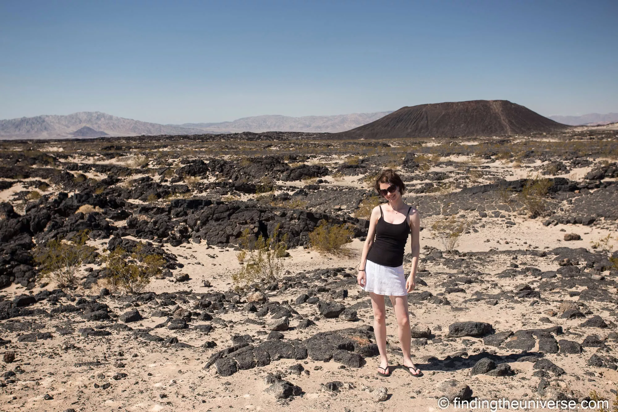
Amboy Crater
Just south of Amboy, a volcanic cinder cone rises out of the flat desert. You can hike to the rim in about 30 minutes, and the views across the lava field are worth the sweat. Free to visit (it’s BLM land), but bring water and don’t attempt it in the middle of summer. We did it in the morning before the heat kicked in.

Bagdad Cafe, Newberry Springs
Made famous by the 1987 film of the same name, Bagdad Cafe is still open and still looks like it fell out of a movie set. The abandoned airstream trailer nearby adds to the atmosphere. Good for a coffee and a photo, and the staff are used to Route 66 pilgrims turning up with cameras.


Elmer’s Bottle Tree Ranch, Oro Grande
An enterprising individual has turned Route 66 roadside rubbish into art. Elmer’s Bottle Tree Ranch is a forest of metal “trees” made from steel pipes and old bottles, and it’s one of the most photographed spots on California’s stretch. It’s free to visit, though since Elmer’s death in 2019 the site has been maintained by volunteers, so donations are appreciated.

Calico Ghost Town
There are towns along Route 66 that have been abandoned since before the road even came along. Once home to over 3,500 people, Calico became a ghost town when the price of silver crashed at the end of the 19th century. Nowadays it’s open as a tourist attraction, managed as a Regional Park, and is very much worth stopping at. Small entry fee.

Barstow
I was hugely surprised by how much freight train traffic there is in the US. Passenger numbers may not be high, but there is a lot of freight plying the railroads. Barstow is a railway town, and the Harvey House at Barstow train station is a former hotel, now repurposed into local administration buildings and museums.


Route 66 Museum, Victorville
There appears to be a Route 66 museum in every state. The first one we visited was in California, and naturally we took advantage of the opportunity to sit inside an old VW and wear wigs and sunglasses. Oh wait, I didn’t need to wear a wig. I just have hair like that already.

The First McDonald’s, San Bernardino
This part of Route 66 is home to the location of the world’s first McDonald’s! We were a little disappointed that we couldn’t have an actual meal here as it’s no longer operational, but we did enjoy peering around the free museum anyway.

I’m not sure anything says Route 66 quite like a giant plastic chicken. And a sign that says Route 66, of course.

Wigwam Motel, San Bernardino
If you’ve always wanted to stay in a concrete wigwam, this is your chance. The San Bernardino Wigwam Motel is one of only two surviving wigwam motels on the route (the other is in Holbrook, Arizona). If you’re looking for more accommodation options, see our full guide to Route 66 era hotels and motels.

Route 66 Signs, Murals and Motel Neon
Sometimes Route 66 is really easy to follow, with giant photogenic signs like this. Other times, not so much. A good Route 66 guidebook is pretty much a requirement. We used the EZ66 Guide by Jerry McClanahan for the whole trip and even met the author along the way.


Route 66 Through Los Angeles
After San Bernardino, Route 66 becomes city driving. The old road follows surface streets through the Inland Empire and Greater LA, which means a lot of traffic lights and not much open-road romance. But there are a few spots worth noticing if you keep your eyes open.

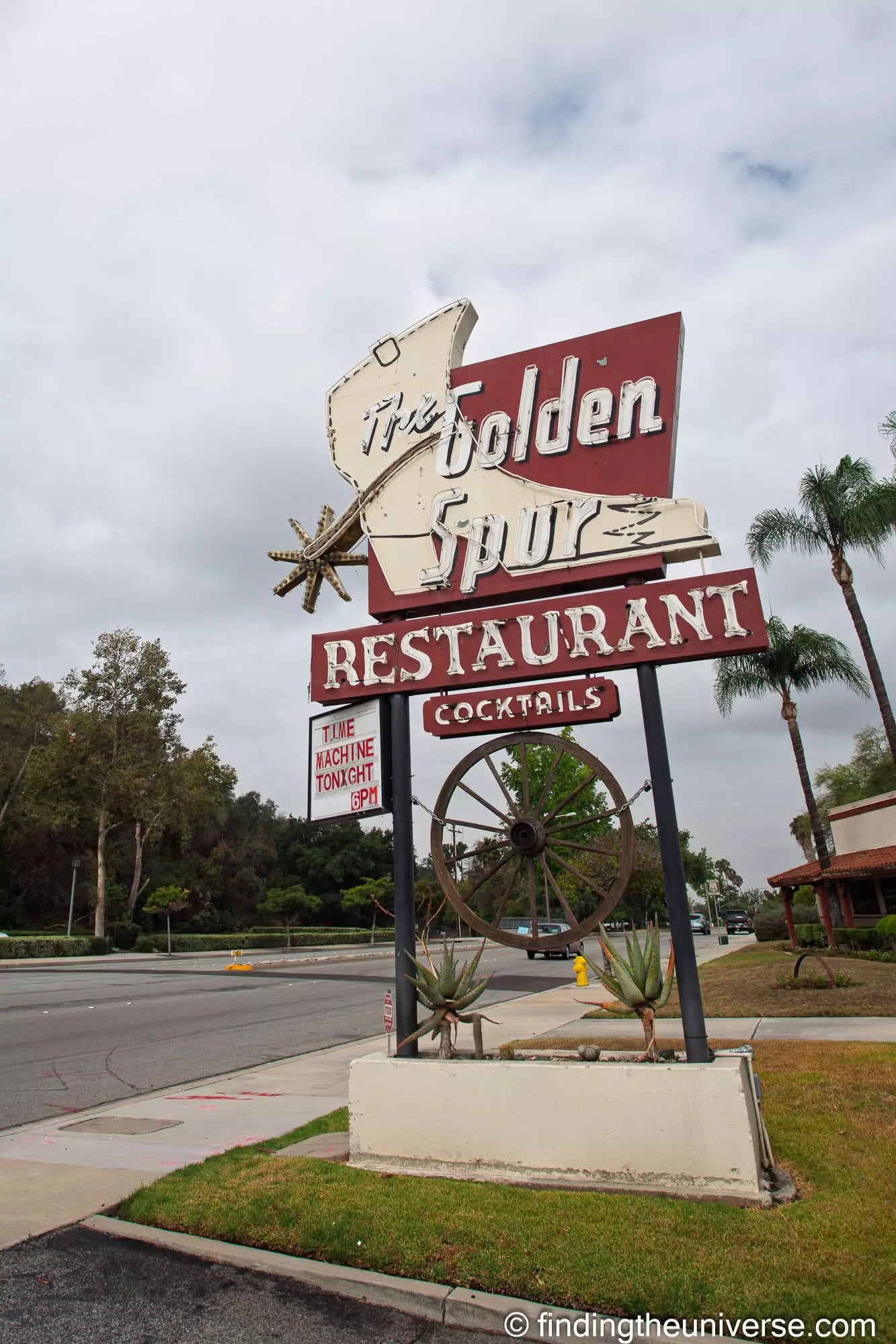
This old gas station in Duarte is one of the last relics of Route 66’s rural past before the suburbs swallowed everything. A few miles further west in Glendora (which renamed its stretch of the old road “Route 66”), the Golden Spur still holds its ground among the newer buildings.
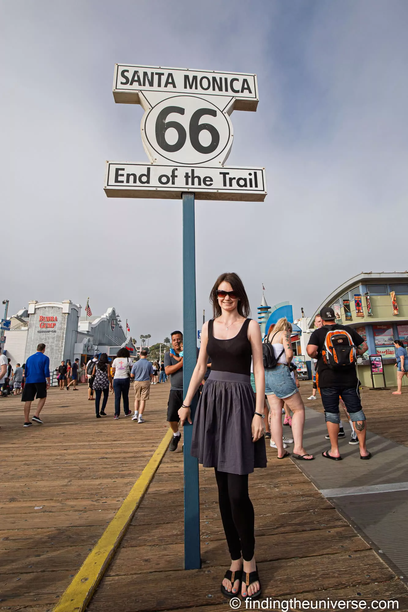
Santa Monica Pier: The End of the Road
Since we drove the route from west to east, the Santa Monica Pier was actually our starting point, not our finish line. We stood at the “End of the Trail” sign (which for us was really the beginning), took the obligatory photos, and then pointed the car east toward Chicago. It felt like a big moment at the time, though we had no idea just how big the drive ahead of us would turn out to be.
For most people driving the traditional Chicago-to-LA direction, this is where the whole journey ends. It’s not the most dramatic finish in the world (it’s a sign on a pier), but after 2,400 miles, I imagine it lands differently, as the Chicago “start” sign did for us.

Driving Route 66 in California
California has about 315 miles of Route 66 between the Arizona border at Needles and the Santa Monica Pier. You could cover it in a day on the interstate, but the old road through the Mojave Desert is worth taking slowly. We spent two days on California’s section and the desert driving was my favourite part of the entire route.
If you’re pressed for time, the two things I’d prioritise are the Mojave Desert stretch (for the scenery and the eerie abandoned buildings) and stopping at Roy’s Motel in Amboy (for the photo and the cold drink).
Be warned: driving through the Mojave in summer is hot. Seriously hot. Carry plenty of water, make sure your car’s air conditioning works, and don’t plan to break down between Needles and Barstow. There’s not a lot out there.
If you need to rent a car for your Route 66 trip, we recommend booking through Discover Cars, which compares prices across all the major rental companies.
For much more detail on planning your Route 66 adventure, Jess has written a comprehensive Route 66 planning guide covering everything you need to know. We also have a detailed 2-week Route 66 itinerary with day-by-day highlights, and a 1-week Route 66 itinerary if you have less time. For accommodation, see our guide to the best Route 66 era motels and hotels.
If you’re new to driving in the US, check out my tips for driving in the USA, and for budgeting, see our guide to travel costs in the USA.
You can also see our photos and tips from the other Route 66 states: Arizona, New Mexico, Texas, Oklahoma, Kansas, Missouri and Illinois.
Frequently Asked Questions
How long does it take to drive Route 66 through California?
California has about 315 miles of Route 66 between Needles on the Arizona border and the Santa Monica Pier. On the interstate you could do it in five hours, but the old road through the Mojave is slower and much more interesting.
We spent two days on California’s section, which gave us time to stop and explore without rushing. If you’re arriving from Arizona, you’ll probably want to overnight in Barstow or Victorville.
Is Route 66 in California safe to drive?
Yes, but the Mojave Desert section requires some common sense. The temperatures between Needles and Barstow can be extreme in summer (we hit 106°F), there are long stretches with no services, and phone signal is patchy. Carry plenty of water, check your tyres and fuel, and don’t plan to rely on roadside assistance arriving quickly.
Can you still drive the original Route 66 in California?
Most of it, yes. Over 90% of the original road is still driveable in California. The urban sections through Los Angeles are still active streets (they just carry more traffic than they did in the 1950s), and the desert sections are largely intact. Some short stretches have been absorbed into I-40 or are on restricted military land.
What Route 66 centennial events are happening in California in 2026?
California has events spread across the whole year. The Main Street of America Centennial Caravan launches from Santa Monica in June 2026, Roy’s Motel in Amboy is hosting its first car show, and the Route 66 Cruisin’ Reunion in Ontario runs every September. The official Route 66 Centennial website has the full calendar.
Gonzalo says
I plan start doing this route this Monday November 25/19 Chicago ,Santa Monica, I hope so everything will be ok
Laurence Norah says
I’m sure it will! Have a great trip, and if you have any questions, let us know 😀
Sam Phillips says
Hi, came across your story about RT.66. We are planning a road trip there in Oct.(not as hot then), only Barstow to Needles..bucket list. Thanks for your words and pics about that stretch of road, we will take our time there. Then back to Portland. Sam Phillips.
Laurence Norah says
October would be a great month for the route! Enjoy your journey, and do check out our one week and two week Route 66 inspiration posts for ideas!
Ken says
Awesome blog. By chance do you remember where the old Airstream was? I have a vintage teardrop trailer and would love to photograph them together.
Laurence Norah says
Hi Ken!
Thankfully I don’t need to remember as my camera has built in GPS 🙂 So it was taken next to the Bagdad cafe, at these co-ordinates:
34° 49′ 11.27″ N, 116° 38′ 36.86″ W
Which you can see on Google maps here:
https://goo.gl/maps/nvwF3j9MY3S2
Would love to see that photo if you get it!
Laurence
nicolas says
Hello,
i really love your picture for the route 66 california highlights. What a shot, west USA as its best in a frame.
Do you remember where is the location with the big horn sheep crossing road sign?
Great website for plan a road trip.
Laurence Norah says
Hi Nicolas,
Thanks very much 🙂 The GPS co-ordinates of the photo are:
34°33’37.614″ N 115°38’32.322″ W – which is here on Google Maps: https://goo.gl/maps/bpnUQR552RK2
I hope you find it 😀
Laurence
nicolas says
Thanks for your reply.
Continue your tremandous job.
Consider Alsace in France for your next trip.
Laurence Norah says
My pleasure Nicolas! I have not visited Alsace, but I did live in the Dordogne for 5 years 😀 We will definitely consider it for our future travels though!